Services Achievements Compare News Pricing Reports FAQ Contact عربي Try Beta
LinkedIn Facebook
🛰️ Syria's Smart Housing Map

Discover Syria's Real Estate Reality From Space

An advanced digital platform delivering precise statistics, satellite imagery, and AI-powered analytics to help you understand Syria's housing landscape and estimate property values by type and district.

Discover building counts, track city growth, and evaluate property per m² — from space to every neighborhood.

Urban analysis of Damascus

Why Syrian Homes?

An intelligent platform for understanding Syria's urban and real estate landscape. We help you see the housing scene like never before.

📊

Precise Housing Statistics

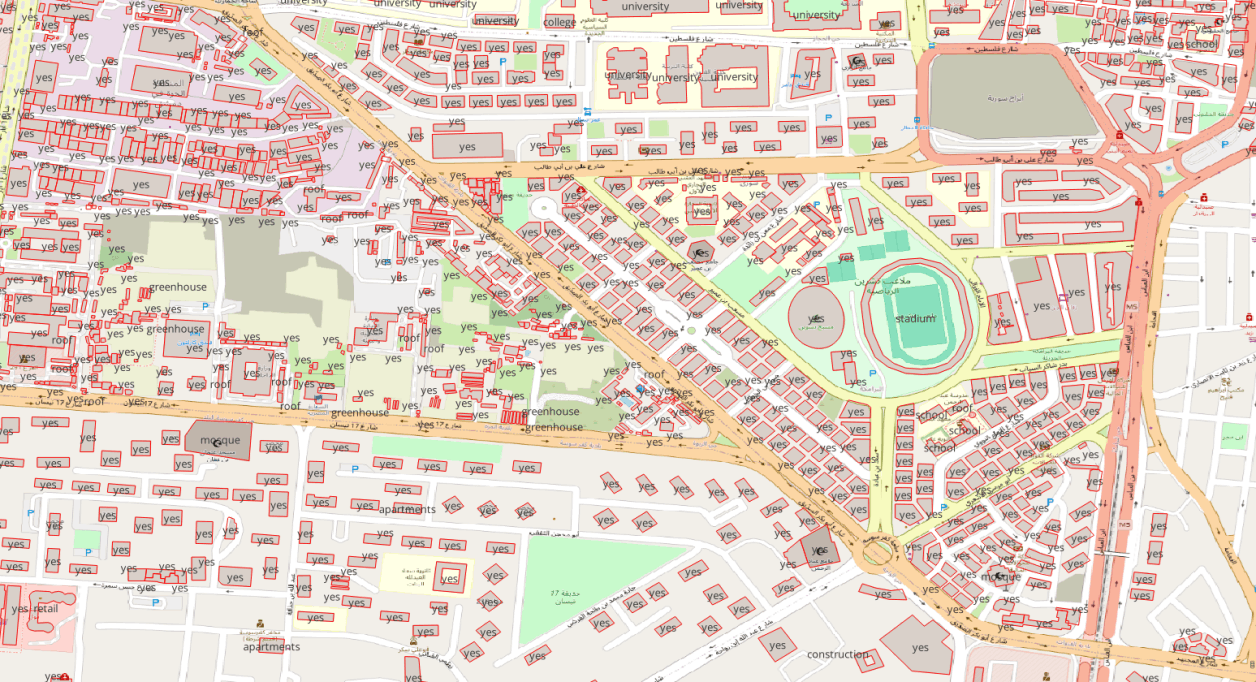
Browse building and unit counts for every city and district, based on reliable data and up-to-date satellite imagery.

🤖

AI-Powered Building Detection

We use modern building-detection algorithms to extract accurate, up-to-date urban information from satellite images.

🛰️

Interactive Satellite Imagery

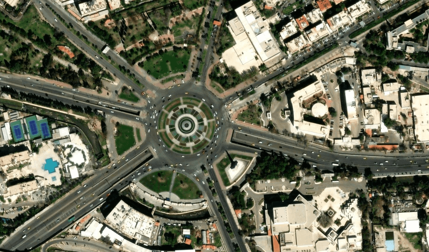
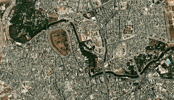
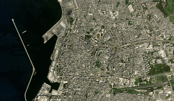
Visually explore Syrian cities from above and see key residential and commercial zones in high resolution.

💰

Price Estimation per m²

Know the price per square meter by district and property type to make confident purchase or investment decisions.

Try the Platform

Toward a More Transparent Real Estate Future

Syrian Homes is not just a map — it's a new vision for understanding Syria's housing and real estate reality, powered by data and artificial intelligence.

Our Cities Like Never Before

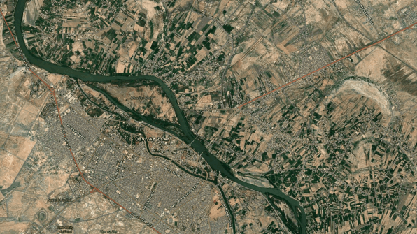
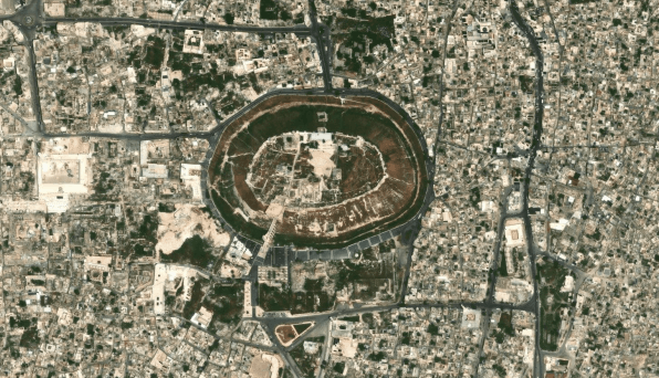
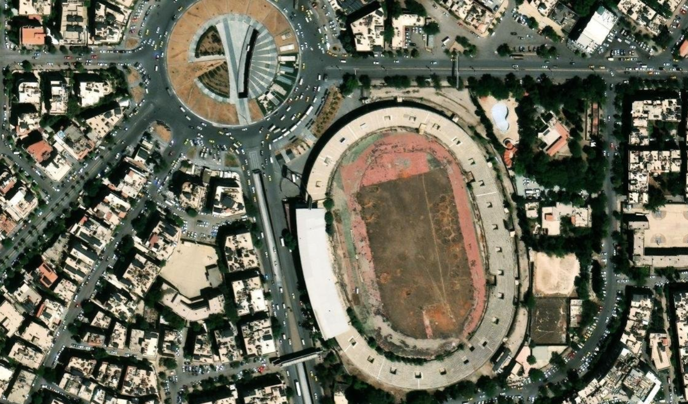
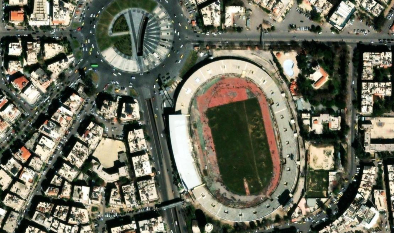
High-resolution, interactive satellite imagery of Syrian cities and neighborhoods

Aerial view of Hama
Hama
Aerial view of Latakia
Latakia
Aerial view of Damascus
Damascus
Aerial view of Deir ez-Zor
Deir ez-Zor
Aerial view of Aleppo
Aleppo

What We've Achieved in 2025

Our milestones in numbers after a year of continuous development and research

0 km²
of Built Area Detected
From high-resolution satellite imagery analysis, the total detected built-up area reached 187 km² of residential and commercial buildings.
0
Buildings Mapped
Over 1,291,448 residential and commercial buildings detected within studied areas, enabling a deeper understanding of urban density and growth.
0 yrs
of Real Estate Coverage
Platform data spans from 2020 to the present, providing a clear timeline of price evolution and market trend analysis.

Our Partners

See the Difference Yourself

Drag the slider left or right to explore and compare satellite imagery between Syrian cities

Damascus — Abbasiyyin Stadium

News & Articles

Our latest updates and real estate insights on LinkedIn

خريطة السكن الذكية LinkedIn
April 2026

Syria is rebuilding — and the opportunity is real.

For companies looking to invest in Syria's reconstruction,
having the right data and the right tools is everything.

Read more
خريطة السكن الذكية LinkedIn
April 2026

خريطة الكثافة السكانية التفاعلية في سوريا

لهذا السبب عملنا على بناء أول خريطة تفاعلية للكثافة السكانية في سوريا بدقة عالية
— مبنية على شبكة سداسية (Hexagonal H3) تُغطي كامل الجغرافيا السورية.

Read more
خريطة السكن الذكية LinkedIn
April 2026

توسيع نطاق تغطية خريطة أسعار العقارات

عد أن كانت الخريطة مقتصرة على أحياء دمشق،
أصبح بإمكان المستخدمين الآن استعراض متوسطات أسعار العقارات بالدولار

Read more
خريطة السكن الذكية LinkedIn
April 2026

خرائط الأسعار تصل إلى مستوى الأحياء — دمشق أولاً

لأول مرة يمكنك مقارنة متوسط سعر المتر المربع بين
أحياء دمشق بشكل بصري ومباشر، مع إمكانية التصفي

Read more

Get Your Apartment Valued
for Just $1

An accurate result built on real market data — within minutes

1
📋

Submit the Request

Choose the valuation service and create your request in seconds

2
💳

Pay Just $1

A nominal fee to ensure report accuracy and quality

3
📝

Fill in the Details

Area, neighborhood, age, floor, and condition

4

Get Results Instantly

A detailed price report delivered within minutes

✅ Large trusted database

Choose the Right Plan

Start free and scale up as your business grows

Most Popular
Professional
$10/month
or $100/year  Save 17%
Everything you need to analyze the market solo
  • 1 user
  • Full Analytics – 14+ reports
  • Property calculator – 100 queries/month
  • Geospatial Maps
  • Helper Maps
  • Building Explorer
  • Email support
Subscribe
For Teams
Business
$500/year
 
Empower your team with full real estate data
  • 5 users
  • Full Analytics – 14+ reports
  • Property calculator – 250 queries/month
  • Geospatial Maps +$300
  • Helper Maps +$300
  • Building Explorer
  • Email support
Subscribe
Enterprise Solutions
Enterprise
$1,000/year
 
A complete platform for institutions and governments
  • 10 users
  • Full Analytics – 14+ reports
  • Property calculator – 500 queries/month
  • Geospatial Maps +$300
  • Helper Maps +$300
  • Building Explorer +$$$
  • Email support
  • Extra users – $100/each
  • 2 live online support sessions/month
  • Custom reports
  • Contact us for a custom quote tailored to your organization's needs.
Contact Us

Subscribe to Our Periodic Reports

Specialized real estate reports delivered automatically — no platform subscription required

📊
Monthly
Monthly Report

A comprehensive report published every month covering major cities — Damascus, Aleppo, Latakia, Homs, Hama — subject to data availability.

$75 / month
  • Price indices for available cities
  • Sales trends and price movement analysis
  • Supply and demand statistics
  • PDF delivery by email
  • Coverage subject to data availability
Subscribe Now
📈
Quarterly
Quarterly Report

An in-depth report published every three months covering major cities — Damascus, Aleppo, Latakia, Homs, Hama — with performance comparison and next-quarter outlook, subject to data availability.

$150 / quarter
Save $75 vs. monthly subscription
  • Everything in the monthly report
  • Comparative analysis vs. prior quarters
  • Heat map of most active areas
  • Market outlook for the next quarter
  • PDF delivery + executive summary
Subscribe Now
📋
Custom
Custom Report

A report tailored specifically to your requirements — a defined geographic scope, a specific time period, or analysis of a particular real estate segment.

Price per
report scope
  • Geographic scope on request
  • Custom time period
  • Specialized analysis as required
  • Multiple delivery formats (PDF, Excel)
  • Pre-engagement scoping consultation
Request a Quote

Note: The periodic reports service is entirely independent of a Syrian Homes platform subscription. Subscribing to reports does not grant access to platform tools or interactive analytics. For inquiries contact us at info@syrian.homes

Frequently Asked Questions

Can't find your answer? Reach out and our team will respond to all your inquiries.

The platform currently covers five major cities — Damascus, Aleppo, Latakia, Homs, and Hama — plus partial coverage of several governorates. Geographic expansion is ongoing based on availability of high-resolution satellite imagery from Maxar and periodic processing cycles.
The platform integrates high-resolution satellite imagery from Maxar, OpenStreetMap geospatial data, AI-powered building detection algorithms, and real estate listing analysis. Property databases are refreshed monthly, while geospatial maps are updated quarterly using newly processed satellite data.
The price estimation tool analyzes actual sales data and historical price indices at the neighborhood and property-type level. Available on paid plans with up to 100 queries per month, it is designed as a decision-support tool rather than a replacement for professional appraisal.
Registration activates a 14-day free trial giving access to a core set of reports and tools. After the trial, the account moves to the free plan automatically. Advanced analytics, geospatial maps, and the Building Explorer require a paid plan, upgradeable at any time.
Property databases and analytics are refreshed monthly when new data becomes available. Geospatial maps are updated quarterly using the latest high-resolution satellite imagery from Maxar. Both cycles are fully automated and require no action from subscribers.
The platform offers more than 10 map types including building density, property value, commercial-to-residential ratio, floor counts, supply and demand heat maps, and infrastructure layers. Specialized geospatial maps are available on paid plans as optional add-ons for Business and Enterprise subscriptions.
The platform is fully compatible with desktop browsers and tablets. Mobile phone support is not currently available because the analytical and geospatial tools require a wider display. For best results, use a screen with a resolution of at least 768 pixels wide.
Four plans are available: Free ($0) for basic use, Professional ($10/month or $100/year) for individual analysts, Business ($500/year) for up to five users with optional geospatial map add-ons, and Enterprise ($1,000/year) for ten users with dedicated support, custom reports, and API access.
Yes, subscriptions can be cancelled at any time with no cancellation fees. Your plan stays active until the end of the current paid period, after which the account automatically reverts to the free plan. To cancel or change your plan, email us at info@syrian.homes.
Yes, a RESTful API is available for subscribers on paid plans, providing programmatic access to property data, analytics, and map layers. To receive API documentation and access credentials, contact the support team at info@syrian.homes or via WhatsApp.
All connections are encrypted with TLS 1.3 and passwords are stored using bcrypt hashing. Role-based access controls and regular security reviews are applied across all data systems. Personal information is never shared with third parties.
Reach the support team by email at info@syrian.homes or via WhatsApp at +963 939 865 975. The team is available Sunday through Thursday from 9:00 AM to 6:00 PM and typically responds within one business day.

Our Team Is Ready to Help

Our team is available to answer all your questions during business hours from 9:00 AM to 6:00 PM.

💬
WhatsApp+963 939 865 975
✉️
Emailinfo@syrian.homes
📍
LocationDamascus, Syrian Arab Republic
🕐
Working Hours9:00 AM – 6:00 PM
📍 Damascus, Syria